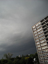
What Is a Nimbostratus Cloud?
Answer:

A nimbostratus cloud is characterized by a formless cloud layer that is almost uniformly dark gray. "Nimbo" is from the Latin word "nimbus", meaning rain. It is a low to middle-level (family C2) stratiform cloud that produces rain, developing cloud bases between the surface and 10000 ft (3000 m). This cloud typically forms from altostratus in the middle altitude range then subsides into the low altitude range during precipitation. Nimbostratus usually has a thickness of 2000 meters. In rare cases, nimbostratus can be very thin and accompanied by a separate layer of altostratus divided by a cloudless layer. Though found worldwide, nimbostratus is found more commonly in the middle latitudes.
The base of a nimbostratus base cloud is dimmed by precipitation and is usually not clearly visible. In all cases, nimbostratus is accompanied by pannus clouds, which develop underneath of nimbostratus. If the pannus layer is completely opaque, the presence of precipitation indicates presence of nimbostratus. The pannus movement is slow and uniform under nimbostratus.
Nimbostratus, stratus, altostratus and stratocumulus clouds all have a smooth gray appearance. There are a number of features allowing an observer to distinguish nimbostratus from other clouds:
- Stratus clouds bring much lighter precipitation (drizzle) than nimbostratus;
- Altostratus clouds are lighter in color and less opaque than nimbostratus, so sunlight can be seen through them;
- Cirrostratus clouds never bring precipitation and have a thin, whitish, veil-like structure, characteristic of cirrus;
- Stratocumulus bring only light precipitation and have clearly visible base with easily distinguished separate cloud elements;
- Large and low cumulonimbus clouds covering most of the sky can be mistaken for nimbostratus. However, they bring heavier, less constant precipitation.
Nimbostratus will occur along warm fronts where the slowly rising warm air mass creates nimbostratus and stratus clouds, which are preceded by higher-level clouds such as cirrostratus and altostratus. Often, when an altostratus cloud thickens and descends into lower altitudes, it will become nimbostratus.
|